You may have seen "How the States Got Their Shapes," but have you ever thought about how our county got its unique shape?
And did you know that Lawrence used to share a border with Hickman County?
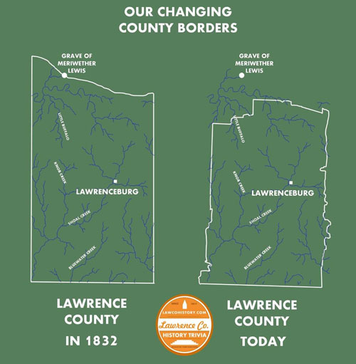
At left is a reproduction of the map made of Lawrence County by Matthew Rhea in 1832, notable for its attention to detail in the county's waterways. At the right are the modern borders of Lawrence County. For comparison, I have overlaid the waterways from Rhea's 1832 map on the modern county borders, despite the fact that several of the streams may have since changed or slightly deviated their courses. But the city of Lawrenceburg and the grave of Meriwether Lewis have not moved in the 183 years since Rhea's map was drawn.
The most dramatic alteration in the county's original boundaries was the creation of Lewis County in 1843. It was formed from parts of Perry, Hickman, Lawrence, Maury and Wayne counties. The grave of famed explorer Meriwether Lewis (of "Lewis and Clark Expedition" fame) was located at one time on Lawrence County's northern border. Today it is several miles inside Lewis County. The explorer met his end at nearby Grinder's Stand on October 11, 1809 of suspected suicide.
Changes in the original ramrod-straight east and west borders of Lawrence County are the result of dozens of private acts of the Tennessee Legislature over the two centuries of Lawrence County's existence. To avoid paying property taxes in two different counties, landowners who lived on the county line often petitioned the state government to include their lands wholly in one county or another. When these requests were granted, it changed the boundaries of the entire county, giving us the crooks and crannies that we see on the modern map.
Shifting boundaries are especially important for genealogists to remember. If you find an ancestor who seems to have jumped the county line, remember that the county line may well have jumped them, instead.