Strong winter storm to impact Middle TN this weekend
NASHVILLE, Tenn. (WKRN) — Middle Tennessee is bracing for a several-day stretch of cold weather this upcoming weekend into next week. With this cold air, there are indicators wintry weather will blanket Middle Tennessee and Southern Kentucky on Saturday into Sunday.
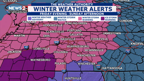
A Winter Storm Warning has been issued for nearly all of Middle Tennessee and Southern Kentucky from Friday evening through Sunday afternoon (heavy mixed precip is expected, including snow, sleet and ice accumulations). There is also an Ice Storm Warning for Decatur, Lawrence, Lewis, Perry, and Wayne counties (where significant icing is expected up to 0.50″). A Winter Weather Advisory is in effect for Franklin, Lincoln, and Moore counties for light ice amounts and snow/sleet accumulations less than 2″.
The chance of snow is highly likely across Middle Tennessee and Southern Kentucky. We will post possible amounts later this evening, this will be a long-lived winter event with effects into next week. There is also a concern for freezing rain and sleet (ice) with highest amounts in southern counties.
The future tracker has the snow moving in early on Saturday morning and becoming more widespread by 9 AM. The latest information shows the chance for freezing rain, sleet, and a wintry mix likely south of I-40 by noon. The pinks indicate that too much warming aloft allows the precipitation to change to rain, then refreeze as ice once it hits the ground. Freezing rain and sleet chances become more widespread across the Mid-State by the afternoon. This could continue into Saturday night which might lead to high amounts of ice accumulation. This would cause major impacts to roadways and increasing concern with power outages.Switching to the European model, Winter precipitation will likely continue all night Saturday into Sunday. Snow could be usher this Winter storm out of the region. Snow will most likely exit the Mid-State by Sunday evening.With the uncertainty of the current set-up with warm air aloft, more discussions will be had about snow amounts vs. ice amounts. We have high confidence to say that all of the region will see some amount of snow. Southern counties (mostly south of I-40 and especially toward Southern Middle Tennessee) will likely have snow and ice. Ice accumulation gets lower as moving north.Make sure you have an emergency kit made up with flash lights, batteries, blankets, first aid, medication and a battery powered radio.
Winterize your home! Protect/insulate pipes, check heating and seal drafts.
Stay informed with up to the minute updates on News 2. We’ll have constant update. By the way, have a communication plan! Be sure to charge your phone up, have a way to communicate with emergency contacts and set a family meeting spot.