Winter Weather Update

Good afternoon weather peeps! We wanted to send some updated information out concerning Friday's winter weather event.
We wanted to stress a few points with the current state of the forecast:
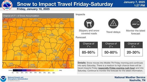
1. The snowfall forecast is still in flux. Overall, the threat for snow has trended up since our update this morning. We now have a 50-80% chance of greater than 2 inches of snow. We are also advertising a 20-30% chance of receiving 5+ inches of snow. If you like snow, this is great news...if not, well we're sorry to be the bearer of bad news.
2. Based on the way things look now, this event should be all snow across Middle Tennessee. The ice should be south of us.
3. The forecast will change. Total amounts could go up, remain about where they are, or, there is a low chance this system goes further south and leaves us on the lighter end of the spectrum.
4. There is a medium to high chance of travel impacts Friday into Saturday. This especially includes rush hour Friday evening, and we're getting concerned about people on the roadways and stuck in the snow.
5. Going to work Friday morning should be okay based on our current forecast, but getting home will be a different story. If you peek out your window Friday morning and think "I'm okay, this snow isn't happening," you might be surprised when it's time to go home Friday evening. Stay tuned to the forecast and be prepared to adjust your plans.
6. Temperatures Friday night, Saturday, and Saturday night will be cold. We don't anticipate too much in the way of melting, so the snow should stick around for a couple days, especially on secondary roads

